


Western Washington faces dramatic “weather whiplash” over the next 24 hours as conditions shift from two weeks of unseasonably warm, wet, and windy weather to a rapid transition into cool, wet, and blustery conditions from Tuesday into Wednesday, creating a turbulent atmospheric shift.
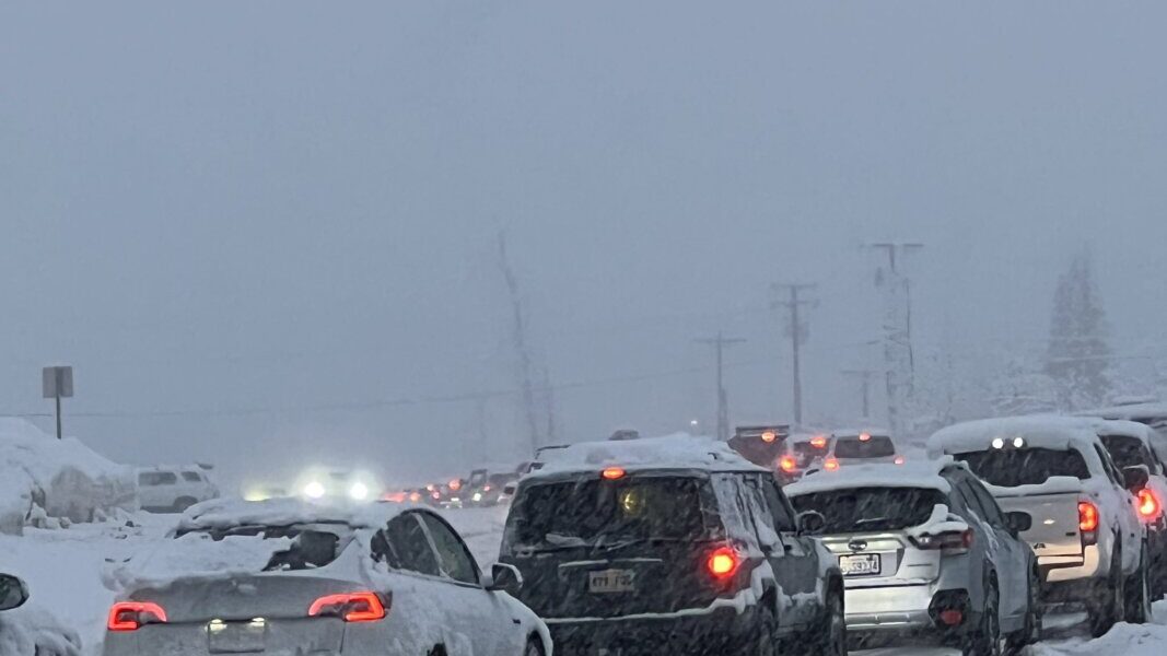
The final round of atmospheric river-driven precipitation is moving through the region now, creating challenging conditions for Tuesday evening commuters who faced blustery south winds and sheets of moderate rain causing low visibility and requiring careful navigation around standing water on roadways.
Drivers needed to maintain firm control of their vehicles, especially across east-west-oriented bridges like the Tacoma Narrows, as gusty southwesterly winds began ramping up to more than 30 mph in the metro area.
Wind speeds will continue increasing overnight, with a high wind warning in effect for much of the region. The southwesterly winds will howl upward of 50 mph into Wednesday morning, creating potentially damaging conditions.
Tree damage and power outages are likely, particularly because the ground has become so waterlogged that entire trees can uproot and topple. The landslide risk will remain elevated as continued rain and wind destabilize hillsides throughout the area.
In the mountains, conditions are beginning with heavy rain up to 6,000 feet elevation, but that snow level will plunge overnight behind a powerful, wet, and gusty cold front. The snow level will drop dramatically to only 2,500 feet by dawn, allowing heavy, wet, blowing snow to accumulate rapidly at mountain passes.
A rare blizzard warning is in effect through Wednesday in the mountains, as blowing snow will create treacherous conditions for high country travel. The volcanic peaks are forecast to receive two feet of snow through Wednesday night, and even the typically bare slopes of Snoqualmie Pass should see nearly a foot of accumulation.
Wednesday itself will bring much more typical late December weather. Rain will transition to showers and sunbreaks, and with cooler air finally in place, high temperatures will reach the seasonable mid-40s around Puget Sound. The heavy snow will become more showery in the Cascades by afternoon, and pass travel conditions should improve as the day progresses.
Wet weather will persist at times into the weekend, but high temperatures will remain mainly in the 40s in lowland areas. This will allow for rounds of mountain snow, quickly rebuilding the snowpack that has been absent for most of the month.
The cool down will also ease pressure on area rivers, with lingering flood warnings on waterways like the Skagit and Cedar finally expiring later this week after days of elevated levels.
Winter begins officially Sunday morning, with Christmas following shortly thereafter. Forecasters hope conditions will be calm and bright by the holiday.
The dramatic snow level drop from 6,000 feet to 2,500 feet represents a fall of 3,500 feet in elevation over just a few hours. Such rapid transitions create dangerous travel conditions as rain at lower elevations transitions to heavy snow at higher elevations along the same mountain highway.
The blizzard warning designation is reserved for severe winter weather combining heavy snowfall with sustained winds of at least 35 mph and visibility reduced to less than a quarter mile for at least three hours. These conditions make travel extremely dangerous or impossible.
The two feet of snow forecast for volcanic peaks like Mount Rainier, Mount Baker, and Mount St. Helens represents substantial accumulation in a short period. Such rapid snow deposition can create avalanche hazards on steep slopes.
Snoqualmie Pass typically sees less snow than higher elevation locations due to its relatively low 3,022-foot summit elevation. The forecast of nearly a foot of snow indicates how cold and moisture-laden the air mass will be.
The heavy, wet snow mentioned in the forecast is particularly problematic. Unlike light, fluffy powder, wet snow adheres to trees and power lines, increasing weight and the likelihood of breakage. The combination of heavy snow and 50 mph winds creates significant infrastructure risks.
The volcanic peaks’ two-foot snow total will benefit ski areas that have struggled with limited snowpack during the warm December. Resorts like Crystal Mountain, Stevens Pass, and Mount Baker will welcome the natural snow.
The transition from rain to showers and sunbreaks Wednesday afternoon follows typical cold front passage patterns. As the front moves through, instability decreases and precipitation becomes more scattered rather than continuous.
The mid-40s temperatures forecast for Wednesday represent seasonally normal conditions for late December in western Washington. After weeks of 50s temperatures, the return to average will feel noticeably colder to residents.
The weekend wet weather continuing with 40-degree temperatures creates ideal conditions for mountain snow accumulation. Temperatures warm enough for liquid precipitation in lowlands but cold enough for snow above 3,000 feet will quickly rebuild snowpack.
The snowpack has been “missing in action” most of December due to warm temperatures keeping snow levels high. This creates water supply concerns for next summer, as snowpack provides gradual melt that feeds rivers and reservoirs.


