

Seattle braces for potentially severe thunderstorms Wednesday evening, with the National Weather Service (NWS) warning of high winds, hail, and a slight possibility of a tornado.
While thunderstorms are uncommon in the region, forecasters predict a 30% to 50% chance of thunder and lightning across Western Washington as a low-pressure system moves inland from the Pacific. Temperatures are expected to reach the 70s before conditions deteriorate.
“This is not a setup we see very often in Western Washington,” said NWS meteorologist Maddie Kristell.
Despite concerns, the risk of a tornado remains low—less than 5%, according to the NWS. However, the storms are expected to bring damaging winds, with gusts potentially reaching 58 mph, and hail up to an inch in diameter, meeting the criteria for a “severe” thunderstorm.
The last significant tornado in the region, an EF-2 twister in Port Orchard in December 2018, damaged dozens of homes and had peak winds of 130 mph—the strongest tornado in Washington state since 1986.
“The threat of tornadoes is unlikely, but rotation or a brief spin-up cannot be completely ruled out,” the NWS noted in a Tuesday afternoon briefing.
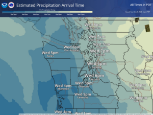
Forecasters expect storm activity to begin over the Olympic Peninsula by 10 a.m. Wednesday, with the strongest storms likely to develop after 5 p.m. west of the Cascades, spanning from Whidbey Island to the Columbia River. The Interstate 5 corridor could experience high winds and hail, with the worst conditions coinciding with the evening commute.
Residents are advised to secure loose outdoor objects, shelter pets and livestock, and stay indoors away from windows.
Following the storms, conditions will stabilize on Thursday, with rain showers and temperatures dropping into the upper 50s. Similar weather is expected on Friday.