


An atmospheric river will deliver two rounds of heavy rainfall into western Washington this week, accompanied by gusty winds that could cause widespread power outages.
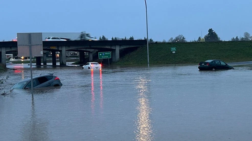
Six western Washington rivers are forecast to reach major flood stage during the multi-day event. The Skagit, Skykomish, Snoqualmie, Puyallup, Nisqually, and Cowlitz rivers all face major flooding projections as rainfall accumulates in mountain watersheds.
The first round of heavy rain will arrive Monday morning and continue through early Tuesday. Areas south of Seattle could receive one to two inches of rain, while locations north of Seattle will see 0.25 to 1 inch of precipitation. The mountains and Cascade foothills will experience 2 to 6 inches of rain with snow levels at 6,500 feet.
Winds will increase Monday, with widespread gusts in the 30 to 40 mph range. Some scattered areas could experience gusts as strong as 50 mph. A wind advisory is in effect for most of the Washington Coast and greater Puget Sound area through Wednesday evening, with the strongest winds expected midday through the evening commute.
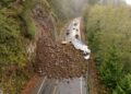
Soil will become very saturated Monday, potentially increasing the damaging impacts of uprooting and downed trees. Residents should prepare for the possibility of power outages at their homes.
The Puyallup and Tolt rivers will crest late Monday night into early Tuesday morning. The Puyallup will crest at major flood stage, while the Tolt will crest at moderate flood stage.
Tuesday will bring a break from the rain during daylight hours as steady precipitation dips south into Oregon. The next round of heavy persistent rain will arrive after sunset Tuesday and continue through Wednesday.
The Skykomish River at Gold Bar and the Snoqualmie River at Carnation are forecast to crest Tuesday evening into early Wednesday morning at major flood stage. These crests will occur as the second wave of atmospheric river moisture arrives.
Heavy rain will continue falling Wednesday during daylight hours before finally weakening Wednesday night. Breezy winds will still be present across the area throughout the day.
Several western Washington rivers will crest a second time in moderate to major flood stage on Thursday. While rain will lighten considerably, showers will still fall across western Washington.
Temperatures will stay mild through the weekend, and snow levels will remain above mountain pass elevations. Light showers will continue through Saturday and Sunday.
The two-wave structure of this atmospheric river creates particularly challenging flood conditions. Rivers that crest Monday or Tuesday will not have time to recede significantly before the second rain wave drives water levels up again Thursday.
The 6,500-foot snow level means precipitation will fall as rain rather than snow across most mountain areas. This prevents snowpack from absorbing moisture that would otherwise be stored until spring melting.
Rain-on-snow scenarios in higher elevations compound flooding concerns. Existing snowpack above 6,500 feet will release water as warmer rain percolates through, adding to runoff volumes beyond what rainfall alone would produce.
The 30 to 40 mph sustained winds, with gusts to 50 mph, create hazards beyond the direct wind damage. Saturated soil loses its ability to anchor tree root systems, making trees vulnerable to toppling even in moderate winds.
Power outages during multi-day rain events create additional hardships. Wet conditions increase electrical hazards, while loss of heating during December cold temperatures compounds difficulties for affected residents.
The wind advisory covering the coast and Puget Sound area reflects forecaster confidence that damaging winds will affect broad areas. These advisories warn the public to secure loose objects, avoid unnecessary travel during peak wind periods, and prepare for potential outages.
The Tuesday daylight break provides a brief respite but may create false confidence. Some residents might assume the event has ended, when in fact the most significant flooding may occur after the second wave arrives Tuesday evening.
Major flood stage designation indicates extensive inundation of areas adjacent to rivers. Properties, roads, and infrastructure in floodplains face significant impacts when rivers reach these levels.
The Puyallup River’s major flood stage forecast particularly concerns Pierce County communities. The river flows through populated areas including Orting, Sumner, and Puyallup, where flood impacts affect thousands of residents.
The Snoqualmie River at Carnation regularly floods the Snoqualmie Valley during major rain events. Agricultural lands, homes, and roads in the valley face inundation when the river crests at major flood stage.
The Skykomish River at Gold Bar threatens communities along Highway 2 corridor. Flooding can close this critical east-west route, disrupting commerce and recreation access to Stevens Pass and eastern Washington.


