


The now-familiar scent of wildfire smoke returned to western Washington on Monday, settling over the Seattle region in a pattern that has become all too common during August. The smoky haze arrived right on schedule, marking yet another summer impacted by poor air quality.
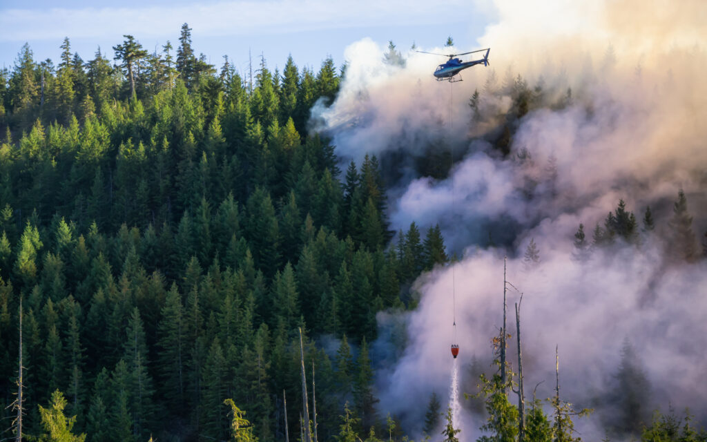
While previous years saw smoke carried in from fires burning in Canada, Oregon, California, or the eastern part of the state, this time the source is much closer, just across the Puget Sound. The culprit is the Bear Gulch wildfire, which has scorched over 4,000 acres near Lake Cushman on the Olympic Peninsula.
It’s rare for the Olympics, often considered one of the wettest regions due to their rain forest ecosystem, to be the origin of significant wildfire smoke. Yet, the dry conditions over the past nine months have left even that lush area dangerously parched. The situation highlights just how dry western Washington has become.
As the smoke settled, air quality across the region dropped. Most urban areas registered levels considered “moderate,” while some sensors reported conditions labeled “unhealthy for sensitive groups.”
This murky mix of smoke and haze can be blamed on several factors. A stubborn marine layer has been lingering along the coast, fueling persistent low clouds. The natural topography of the Puget Sound basin, hemmed in by the Olympics and Cascades, creates a bowl that traps air. Dry conditions and a lack of rainfall have allowed pollutants to accumulate, and a ridge of high pressure has effectively sealed the haze in place. The final and most immediate ingredient has been the Bear Gulch fire feeding smoke directly into the region’s already murky atmosphere.
But relief is on the horizon. An early-season cold front is expected to push into western Washington over the next 48 hours, bringing with it something we haven’t seen in weeks, rain.
The shift will begin Tuesday with morning cloud cover and limited sunshine by afternoon for the Seattle area. Temperatures are expected to reach the low to mid-70s, stretching from Poulsbo to Carbonado. Along the coast, spots like Ruby and Rialto Beaches are likely to see the first summer showers arrive by Tuesday afternoon.
The cold front is projected to move across the Puget Sound late Tuesday into early Wednesday, delivering a much-needed soaking rain. Forecast models suggest the greater Seattle region, along with nearby cities such as Sammamish and Silverdale, could see anywhere from a quarter to a third of an inch of rain, with higher amounts possible in some spots.
Areas like Forks and Mukilteo could receive up to three-quarters of an inch. Even the typically drier regions like Winthrop and the eastern slopes of the Cascades are expected to collect a few tenths of an inch. The western slopes of both the Olympics and Cascades are forecasted to benefit from even more rainfall.
This midweek rain system comes at an ideal moment. Not only will it help reduce fire risk, but it’s also expected to clear the skies of smoke and improve air quality across the region.
By the weekend, clearer skies and warmer temperatures are anticipated, with highs nearing 80 degrees in Seattle. If conditions hold, residents may finally enjoy some fresh air and a brighter blue sky to close out the week.


